A blast of Arctic air is sweeping the eastern two-thirds of the United States, moving millions to bundle up against freezing temperatures earlier than usual and putting people as far south as Texas at risk for snow and ice.
About 70% of the US population is expected to see temperatures at or below freezing by Wednesday morning, and hundreds of records are expected to fall with temperatures generally 20 to 40 degrees below normal.
Travel could be tricky especially in 15 states from Texas to New England, where snow and ice could accumulate. Elsewhere, parts of the Deep South are under freeze watches, warnings or advisories, including South Texas and the Florida Panhandle.
“(It’s) a quick-hitting, but very, very cold blast,” CNN meteorologist Chad Myers said.
Snow has fallen over the past day from the Midwest into the Northeast, with more on the way. Even Gatlinburg in eastern Tennessee received at least 1 inch of snow by early Tuesday — Gatlinburg’s SkyLift Park posted video of snow covering North America’s largest pedestrian suspension bridge.
In the Northeast, cities including New York, Philadelphia and Washington started out with rain but could end the day with snow.
A snapshot of how cold the country has been:
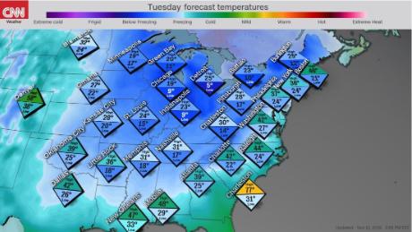
• Cities including Indianapolis; Wichita, Kansas; and Amarillo, Texas, broke lows for November 12 that were set in 1911. Amarillo got down to 7 degrees Tuesday, beating the old record of 10.
• Nashville was at 23 degrees Tuesday morning with a wind chill of 10, after a high of 63 the day before.
• Nearly 3 million people experienced below-zero temperatures, with readings as low as minus 11 in northern Minnesota.
• New York City is expected to be around freezing by Tuesday evening, after temperatures in the mid-50s.

Snow could challenge travelers in the Midwest and Northeast
Snow and ice already have caused issues for flights.
Heavy snow also is expected in upstate New York into New England.
CNN’s Maddie Capron contributed to this report.
Source : Nbcnewyork


