
Tropical Storm Pabuk is expected to make landfall about 7 p.m. local time Friday (5 a.m. ET) near the Chumphon archipelago, on the eastern border of Thailand’s Surat Thani and Nakhon Si Thammarat provinces, but heavy rain has already arrived.
Some of the country’s most popular tourist destinations, including Koh Samui, Koh Phangan and Koh Tao islands, along with islands in the Andaman Sea such as Phuket and Koh Phi Phi — made famous by the movie “The Beach” — are expected to be affected by the storm during peak holiday season.
“It’s quite scary being here because we don’t know what’s going to happen and there is no way to leave,” American tourist Miranda Abidyer, 26, who is stranded on Koh Samui island, told CNN.
Abidyer, who traveled to the island with her young family to celebrate her husband’s 30th birthday, said they had a flight scheduled for Friday but it was canceled and ferry services have also been suspended. She said they haven’t received any information from local authorities about the storm or what they should do. The now plan to wait it out in their private villa, which is about 1 kilometer (0.6 miles) from the beach.
“We will hide in the bathroom if the storm gets that bad. But all we can do is wait,” said Abidyer.
It is highly unusual for tropical storms and typhoons to make landfall in Thailand. The last time a tropical storm made landfall in Thailand was in 1962, when Tropical Storm Harriet impacted 12 provinces and claimed 900 lives. The only typhoon ever to make landfall in the Southeast Asian nation was Typhoon Gay in 1989.
The district chief of Koh Samui, Kittipop Roddon, told CNN by phone Friday that there are about 20,000 tourists staying on the island, which is the second largest in Thailand.
“The island is now totally cut off from the mainland, all kinds of transportation (to mainland) have been suspended since yesterday,” he said, adding that there is enough food and supplies on Koh Samui to last through the storm.
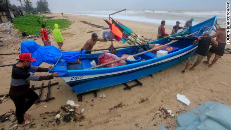
Those left are now preparing to ride out the storm, with residents on Koh Samui boarding up houses with wooden planks. By Friday, the roads on the island were quieter and store shelves emptier, witnesses told CNN.
But it’s those on some of the smaller islands that could be the most vulnerable. The district chief of Ko Phangan and the popular diving island of Koh Tao told CNN that he was concerned that any emergency rescue operations would be more difficult on Koh Tao due to its remoteness. He said 15,000 tourists remain on Koh Phangan and about 4,000 on Koh Tao.
Thousands of residents living in coastal areas were evacuated to storm shelters on Thursday, according to Thailand’s Disaster Prevention and Mitigation agency. Some 5,700 people were moved to safety in the province of Nakhon Si Thammarat, on the country’s east coast, which is among the areas expected to be hardest hit by the storm.
The agency’s director general, Chyapol Thitisa, told CNN that for three days the army had been helping to evacuate those living in remote and coastal areas in the province and some coastal villages prone to storm surges have been completely emptied.
Thousands of tourists have also fled the islands, cramming onto ferries and specially chartered boats.
Nakhon Si Thammarat airport is closed, and Bangkok Airways announced the cancellation of all flights to and from Koh Samui on Friday “for safety reasons.”
Thailand’s Meteorological Department said the storm was 150 kilometers (93 miles) southeast of Nakhon Si Thammarat province, according to a 7 a.m. weather advisory on Friday.
Tropical Storm Pabuk is expected to bring maximum sustained winds of 95 kilometers per hour (59 mph) and torrential downpours. Strong winds on Thailand’s gulf coast, which lies directly in the path of the storm, could bring waves up to 3-5 meters (10-16 ft), according to the Meteorological Department.
After crossing the Chumphon Archipelago the storm will, if the current track holds, make a second landfall over Surat Thani province early Saturday.
Pabuk will then move over the Malay Peninsula towards the Andaman Sea relatively quickly, but not before dumping large amounts of rain across the region.
The storm is expected to bring strong winds, high waves and surf along with surge, and heavy rain with flooding. While the winds, surf and surge will be dangerous especially, to an area not used to seeing these types of storms, the most significant danger is the rain and flood potential.
Areas in the southernmost portion of Thailand could receive well over 250 millimeters (10 inches) of rain. There is also the possibility of mudslides from the Phuket mountain range on the western side of the peninsula.
The province likely to be worst affected is Nakhon Si Thammarat, where Tropical Storm Harriet hit in 1962.
As the storm progresses out to the Andaman Sea and towards the Bay of Bengal into next week it could become a problem for the coasts of Myanmar, Bangladesh and India.
CNN’s Euan McKirdy contributed.
Source : Nbcnewyork


