
Tornado watches for areas around Houston and College Station were lifted early Wednesday, but the rain is expected to continue falling until Friday before the system makes its way to the Gulf of Mexico.
Coastal areas in Texas should expect rain through Monday.
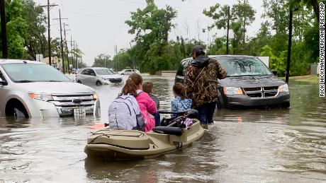
From late Tuesday and into Wednesday, between 3-5 inches of rain had fallen. Life-threatening flash flooding was ongoing or expected to begin shortly in creeks and streams, urban areas, highways, streets and underpasses.
In the coastal city of Port Lavaca, the fire department urged residents to stay home and off the roads until the storm passed after receiving multiple reports of stranded motorists.
Deadly damage in Louisiana
“Had their machines been working, there is no doubt in my mind they would be alive today,” Evans said.
The Louisiana State Patrol said a crash Monday night in West Baton Rouge Parish left one person dead, another missing and others with minor injuries.
The vehicle left the road and went into a canal where it sunk, state police said in a news release.
In neighboring Arkansas, the National Weather Service issued flash flood warnings early Wednesday.
Extreme rainfall closely linked with the climate crisis
“The frequency and intensity of heavy precipitation events across the United States have increased … and are expected to continue to increase over the coming century,” according to the US National Climate Assessment in 2018.
This is leading to more 1-in-5-, 1-in-10-, 1-in-100-year-type extreme rainfall events that lead to catastrophic flash flooding.
These trends are consistent, according to scientists, with what is expected in a warming world, as warmer temperatures cause more evaporation which leads to higher levels of water vapor in the atmosphere, which can in turn lead to more frequent and more intense rainfall.
Louisiana has experienced extreme, climate-fueled rainfall before with disastrous consequences, such as in 2016 when deadly flash floods were studied by scientists and found to have been made at least 40% more likely and 12% to 35% more intense because of human greenhouse gas emissions.
Source : CNN


